My last visit to the Manti-La Sal project was in January 2010 on a photo trip with my friend Jeremy Long. I visited again over Memorial Day weekend in 2018 to survey the work we did and provide a report on the results after 10 years.
Skip To: Joe’s Valley Reservoir | Dry Wash | Buckhorn Draw | Buckhorn Side Canyons | Other Notes
As with any project of this magnitude, there were highlights and some lessons learned.
Joe’s Valley Reservoir
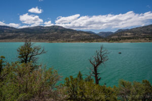
Joe’s Valley was the principal area of the Manti-La Sal National Forest we worked. The majority of the project occurred in the Buckhorn Wash area of the San Rafael Swell managed by the Bureau of Land Management.
Joe’s Valley is a man-made reservoir that dams the snowmelt inflow of at least 3 principal creeks which come from the South, West, and North. The circumference of the lake is approximately 7 miles. At an elevation of 7,500 feet, this lake represents some of the highest advance of Tamarisk into mountainous terrain.
Unfortunately, while the work from 2008 was obvious, there was significant tamarisk growback in many areas of the lake. I have some ideas on why this has occurred:
- In 2008, the waterline was higher due to a large snowpack in the previous winter season. In fact, when I visited in April 2008, the lake was still frozen over. Utah has had a drought, with a lower waterline, exposing many of these shoots. In addition, our herbicide was not used at the waterline, leaving some Tamarisk to escape unscathed.
- Tamarisk like sandy and disturbed soils, which is why Desert Southwest wash drainages are so hospitable to them. I observed much of the regrowth in areas of sand, particularly in areas with frequent foot traffic. Boat launches, marinas, and access areas for fisherman all had common regrowth. Perhaps human foot traffic is providing access for seeds to germinate.
- The worst growth was to the South (Lower Joe’s Valley). There are two creeks in this area, Fuller Creek and Bubs Creek, and there just may be more water. I also suspect that there may be some natural oscillation in the lake since the dam is slightly closer to the South than Upper Joe’s Valley.
- The last idea has to do with the lake itself. Although the lake level can be variable, it is more or less a permanent water source, providing plenty of room for Tamarisk to thrive.
There were a couple reasons to be optimistic despite the results. There were vast areas of grass and the original cuts by the teams were obvious. Acres of area had natural grasses instead of Tamarisk.
Another reason to be optimistic is that nearly all of the Tamarisk were juveniles. I imagine that if the United States Forest Service put some additional work into the lake, they could wipe out much of the remaining Tamarisk.
Finally, I looked in many areas of Cottonwood Creek, which is the outlet from Joe’s Valley Reservoir. I could not spot a single Tamarisk. This likely means that the Tamarisk seeds probably arrived via foot traffic or from birds. There is reason to think that if the Tamarisk can be removed in subsequent rounds, the removal could be more or less permanent for a generation.
Overall, there was much to be proud of. The areas we had access to above the water line, appear to have been cut well. Thank you to Joan Armstrong for her leadership with the support of Deputy Scott “Mac” McLeod around the entire reservoir. The Forest Service would be good to follow this up during a drought season and do a quick removal of the areas that we apparently couldn’t reach during a high water year.
Click on any image below to view the complete slideshow.
Dry Wash
Dry Wash is located just outside of Ferron, Utah, near the location of the Manti-La Sal National Forest’s field office. The wash is one of the drainages that feeds into Millsite State Park. In March and April 2008, while working closely with John Healy of the USFS, we became concerned about the snowpack at Joe’s Valley and the ability of our staff to reach the tamarisk at the water line.
John suggested to Mark Stickel and I that we investigate clearing tamarisk from this drainage. It is actually a set of winding drainages leading from the mountains above. As it turned out, the water line at Joe’s Valley was less a problem than we envisioned (albeit one with mixed results as noted above), but we chose to keep Dry Wash as part of the project.
Mark’s group cleared from the State property line up for a couple miles. I was pressed for time, but I visited this area. I was actually a little disoriented because in 2008, the huge wall of tamarisk on the State Park was our clear giveaway that we were in the right area.
In the Dry Wash area, I found no tamarisk at all. I was also pleasantly surprised that the State Park had apparently done a lot of work clearing their own area. Although there was some tamarisk here and there in the State area, it looked like a completely different area. I chose to move on, because I had a lot of work to do in Buckhorn so I didn’t take any photographs.
Back to top of page
Buckhorn Draw
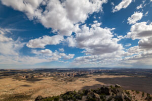
Buckhorn Draw was the centerpiece of the ArrowCorps5 project. This is technically BLM land, although the larger set of projects were principally designed to benefit the United States Forest Service. This area was led by a great group of Division Leaders, including Moses Winston, Jack Renforth, and Ken Hedrick.
Our success in Buckhorn was the principal measuring stick for how our project would last over time. I was ecstatic to see something like a 95% kill rate up and down the 11.5 miles of the canyon. There were some very isolated spots with small tamarisk. The pin flags I saw in 2008 were gone. Perhaps the BLM followed through the canyon at some point.
There were two springs listed on the Topo Map inside the Draw. They were definitely dry in 2008 when we removed the plants responsibile for draining them. We speculated about how long it make take for these springs to recharge. James Arriola, Logistics Section Chief, mentioned at the time that locals said there used to be a perennial creek at one point.
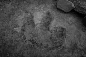
While I had the stream was back, I can report that is not the case. The springs are not recharged. That being said, it appears the creek is running underground, judging by how hearty and healthy the cottonwoods looked in a drought year. I believe in time, the springs will fully recharge. I found several spots, principally lower in the canyon that had standing water. This wasn’t spring water, but likely rain that had not evaporated. The cottonwoods help this process, by providing cover through the creek that slows the rate the creek loses water. This will help in the long-run.
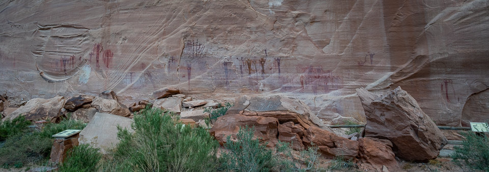
Slash piles were still evident, particularly in the thickest areas just North of the Swinging Bridge and by the Pictograph Panel. I did note in the 8 years that had passed since I last visited that the slash piles were much smaller. They are decaying, and the ground cover below does not have tamarisk growing back. Most areas have small grasses and other vegetation. One can hope those areas in time will sprout a couple new cottonwoods. That would be quite a treat; no cottonwood will grow when surrounded by tamarisk.
Click on any image below to view the complete slideshow.
Side Canyons
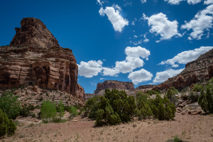
Buckhorn Draw is certainly a major canyon leading into the San Rafael River, but you have to be in the canyon to truly understand the deep and expansive system of side canyons that lead into Buckhorn.
The side canyons were a particular challenge in 2008. Many are difficult to traverse, have large obstacles, dry falls, and require some level of bouldering. Bill Topkis led this group, and they committed to following all of the side canyons throughout all of Buckhorn. In the heat and humidity, this was a strenuous job for some tough Scouts and Scouters.
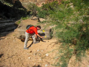
Using the tamarisk map made by Utah State University, a lead group would head up each canyon to plant pin flags ahead of the Scouts. At the point where the tamarisk advance ended, they added 3 parallel pin flags.
There simply wasn’t enough time to visit all of the side canyons, so I had to choose. One factor was the heat, in the 90s, as well as humidity coming in from some early monsoons. In short, it was very much like our 2008 ArrowCorps5 weather! Any time you have this kind of weather, and a chance of rain, flash flooding is a concern for being in any canyon.
I checked both Schultze and Topkis canyons (yes, we named stuff after ourselves!) and found no tamarisk at all. These two canyons had sparse infestation in 2008, and seeing how well Buckhorn Draw was doing, this didn’t surprise me. I couldn’t go up canyon all the way, principally because I just didn’t have that much time, but I remembered approximately where Bill and I added our 3 pin flags.
The other obvious candidate was the Calf Canyon complex. This by itself is an extension canyon system in it’s own right, with Pine and Cow Canyons branching from it, as well as several smaller and Order of the Arrow named canyons. Calf and Cow Canyons were host to very extensive tamarisk in 2008, although not as thick as Buckhorn.
There was one canyon named after our friend Steve Silbiger, Silbiger Canyon. While Steve is one of the nicest and most easy-going guys in the world, this canyon was not! There was a seep draining from the canyon top that was providing plenty of water to the drainage below. This canyon was also small, and barely discernible on a topo map. In fact, it appeared the side canyon was completely missed by Utah State University! When our side canyon located it, they were in for a shock because the tamarisk were huge and massive. We had to divert nearly all of our chain saw crews to pull out huge trees. Our work in the main canyon halted, as we had to audible and take care of a huge unplanned mess.
My lead Deputy, Scott “Mac” McLeod, headed up this group, and we diverted as many fit crews and squads as we could. As I went up Pine Canyon, which branches off Calf Canyon by the Renforth Face (another OA namedrop), I headed up the canyon.
So here’s the thing. I found nothing! Only huge dry falls, huge boulders, and canyon sides full of virgin, untouched, crypto soil. And man, it was hot. My eyes were stinging. I had already finished my water. I came to the conclusion that 10 years had passed and I was in the wrong canyon. I didn’t see any tamarisk, and I didn’t see any evidence of removal. Considering my largest wood cuts that were given to me by the sawyers are huge, I concluded I was up the wrong canyon.
Sorry Steve, maybe next year I will have a chance to check your canyon out.
Click on any image below to view the complete slideshow.
Other Notes
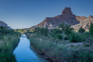
At the Swinging Bridge, the tamarisk infestation was so thorough and complete, it was hard to even see the San Rafael River from anywhere other than the middle of the bridge. I was surprised to see the river largely clear of tamarisk. What a sight to see. The river looked much different! Obviously, the BLM had followed up our project with some fantastic work of their own. It was beautiful to see!
Buckhorn Flat is the area above Buckhorn Draw. I was disappointed to find the tamarisk in the same areas as 2008. I think the larger attention paid to Buckhorn Draw’s canyon system (during ArrowCorps5) and the San Rafael River (by BLM after our project) may be why these areas have been missed. In some of the old cattle areas, the tamarisk was a large and thick as ever. Areas where water drained had some here and there.
While the volume of tamarisk wasn’t great, it provides plenty of opportunity for seeds to make their way back down the canyon.
Order of the Arrow Pages
- ArrowCorps5 Manti-La Sal Archive
- California’s First Vigil Honor Recipient
- Conclave Theory – Promotions
- Creating A Historical Archive
- Happy 20th Birthday Snakepower.org
- How Demographic Changes Affect The Program
- I Was Never Nominated For The Vigil Honor
- Lodge Historians – What To Do With Photography
- OA Collecting
- Arrowhead Patches
- Bullion Patches
- California Neckerchiefs
- California OA Collecting
- Camp Patches and Collectibles
- Chenilles
- Jacket Patches
- Leather Patches
- Non-OA Society Patches
- OA CSPs
- OA Multi-Piece Patch Sets
- OA Neckerchiefs
- OA Odd Shapes
- OA Round Patches
- Patches I Owe Bill For
- Patches I Owe Nick For
- Patches I Owe Thom For
- Pocket Flaps
- Rounds
- OA Pocket Flap Bait And Switch
- Order of the Arrow Pages Background
- Photography’s Role In Developing OA History
- Pre-OA Societies In The Inland Empire
- Rethinking Chapters
- Thank You
- You Are Doing Social Media Wrong
