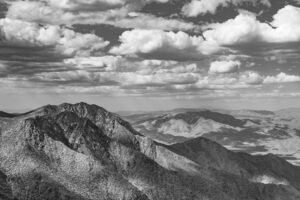
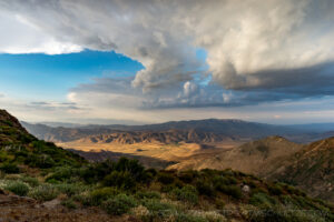
This is a list of some of the Overlooks and Scenic Points I enjoy in East County (in San Diego County).
Interstate 8 – Sweetwater River Vista Point
This location is right off Interstate 8. The circular part of the parking lot follows the old “Deadman’s Curve” on Old Highway 80 before the freeway was put in. This can be a challenging viewpoint as you have a narrow view West directly above the Sweetwater River Gorge.
Old Highway 80 – Wildwood Glen Lane
This is a well-preserved section of Old Highway 80 that is now closed to vehicular traffic. The entire section is about 1.5 miles long and offers a number of viewpoints.
Note: As of Spring 2020, the road is partially closed to foot traffic due to an upgrade of a power line upgrade. Here’s hoping they don’t damage the original concrete.
Sunrise Highway – First Overlook
This first overlook is just North of Interstate 8. There is a turnoff on the Northbound side looking down a canyon to the East. At night, you pick up a lot of light pollution from the Interstate 8 Border Patrol checkpoint.
For much of 2019, this overlook was closed due to work on the electrical transmission line heading to Mt. Laguna.
Sunrise Highway – Second Overlook
This second overlook is just past the First Overlook. On the Southbound side, there is a very large dirt area looking West. This can be a very nice location for sunsets. On the Northbound side, there is another parking area. This is the area where you can try to hike and locate Cottonwood Falls, a small cascade of Cottonwood Creek.
I have yet to get a photo of the creek with water at the falls.
This is also the section where Old Sunrise Highway is located. It branches off from the current, improved road, as it takes a lower traverse of the canyon. Following the telephone lines is an easy way to see where the old road is located.
For much of 2019, about 70% of the Southbound side has been closed due to work on the electrical transmission line heading to Mt. Laguna.
Sunrise Highway – 3 Turn-Out Overlooks
After driving past Crouch Valley and the Sunset Trailhead, Sunrise Highway veers South to make a traverse around the mountains on its way to Mt. Laguna. This road is also a bypass of an earlier Old Sunrise Highway. On this grade, there are 3 turn-outs that have overlooks.
The only one I recommend is the 3rd turn-out after Kitchen Creek Road if proceeding North (or before if going South). It has a clear view of the South which can be nice when there are nice or dramatic cloud formations.
The telephone line can be in the way, depending on how wide of an angle you are using, so locate it before framing your image.
Sunrise Highway – Stephenson Point
While Stephenson Peak is generally off-limits due to the presence of former Mt. Laguna Air Force Base and the associated radar station, there is a beautiful view of the lower desert of Anza Borrego.
Sunrise Highway – Foster Point
This is a short hike from Sunrise Highway near the Horse Heaven campsite turnoff.
The trail takes you to the Pacific Crest Trail, and then to the Foster Point Trail, offering one of the most dramatic views in San Diego County.
Sunrise Highway – Storm Canyon Overlook
Most people go to the improved Forest Service overlook with the deck. This is a nice spot, but it’s often crowded and the view is obscured. Some dead pine from the Chariot Fire is in the way. You can walk below the deck to the adjacent Pacific Crest Trail. There is a bench to stand on for an overlook image.
I would recommend you proceed North for about a half mile. There is an unmarked overlook that is even better, and you are likely to be there by yourself. It appears that there is some remaining dirt track from an earlier Old Sunrise Highway. The view is great.
This can be a very windy location, so plan ahead.
Sunrise Highway – Garnet Peak
Garnet Peak is both the most photogenic peak and perhaps the most fun peak to hike in San Diego County. There is a small parking area past the busy Penny Pines parking area. The trail takes you to the Pacific Crest Trail where you meet the final ascent. It’s steep, but a short hike with one false summit.
The top of the peak is spectacular as it is small and rocky. It feels like you climbed a proper peak. The views in all directions are incredible. Like elsewhere in the Laguna Mountains, getting there on a day with calm winds is a bonus.
Sunrise Highway – Kwaaymii Point
Kwaaymii Point is another section of Old Highway 80. The road is the former highway, and it continues from the modern cul-de-sac all the way back to Pioneer Mail. This old road has also been purposed as a section of the Pacific Crest Trail.
When conditions are right, this is one of the best overlooks in all of San Diego County. There is a clear view of Whale Peak and the lower Borrego Desert.
This is also one of the windiest locations in all of San Diego County. A calm day at this spot is rare. There are often ferocious winds that will rock your parked car back and forth. It’s a good idea to be ready for wind before stopping to make an image.
Sunrise Highway – Oriflamme Overlook
Sunrise Highway – Granite Mountain Overlook
Highway 78 – Santa Ysabel Overlook
Mesa Grande Road – Henshaw Valley
Mesa Grande Road is a very cool backroad that connects Highways 79 and 76. However, one thing it doesn’t have is anywhere to park. That makes several spots difficult to photograph. From Highway 76, headed South, there is a small dirt parking area that can fit one vehicle. There is a nice view of the Henshaw
East Grade Road – Henshaw Scenic Vista
This is a US Forest Service Scenic Vista with a very nice deck. The view is over the entire Henshaw Valley, including the Lake, Hot Springs Mountain, and Warner Springs.
Some improvements at the Santa Ysabel Indian Reservation, particularly at the former casino, can be found in the distance. You can clone those out of any image you make.
There is potential for a good sunrise here, but I haven’t achieved that yet.
Note: As of Spring 2020, this overlook is closed due to the Coronavirus pandemic.
East Grade Road – Love Valley View
Lyons Valley Road – Corte Madera Overlook
Proctor Valley Road – San Miguel Mountain View
Old Highway 80 – Buckman Springs Bottling Plant View
Highway 94 – Railway View
Carrizo Gorge Road – Round Mountain View
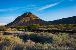
At the Interstate 8 Jacumba Exit, most people exit to get gas. In fact, Jacumba Hot Springs is several miles South of here. But if you follow the dirt road West, there is a beautiful view of the San Diego-Arizona Eastern Railway and Round Mountain.
Don’t drive too far though, or you will end up at the De Anza Springs Resort, which is a nudist colony.
The railway is a way (illegal – trespassing) that people go to see the Goat Canyon Trestle, but you should only approach by legal means.


