This past week, a couple of hikers found Bill Ewasko1, missing in Joshua Tree National Park for nearly 12 years. I was delighted at this news and hope this brought his family some closure, and had some personal thoughts of my own on how we seek destinations known and unknown, and the dangers that wait.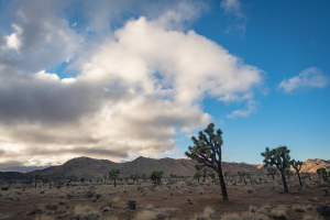
There really hasn’t been a moment since 2010, especially in the middle of the park, that I haven’t thought about Bill. This was especially true looking at Quail Mountain, the highest point in JTNP and thought to be his intended destination on June 24, 2010. What was ostensibly meant to be a day-hike, turned into a search-and-rescue operation, and he wasn’t located. The only scant evidence was his vehicle, parked at Juniper Flat and found on the 26th, and later a faint cell phone ping that was estimated at a distance of 10.6 miles from the Serein Road cell tower.
It should be noted, that for all its vastness and remote wilderness, people are rarely lost in Joshua Tree National Park. The vast majority of deaths come from rock climbing accidents. People lost, and people not found, are exceedingly rare. For Bill Ewasko to not be located, it was clear that something unfortunate happened, and he was in a difficult area to find and access.
After several days of searching, including by helicopter after the cell phone ping, the search was called off. Wherever Bill was, he was to be there for a long time.
Tom Mahood, formerly of the Riverside Mountain Rescue Unit and the person who located the Death Valley Germans, began a personal quest to find Bill. Tom made no fewer than 44 individual trips throughout the area, carefully GPS-mapping his searches, sharing his thoughts, and documenting all of his data on his excellent website. Others followed his lead, conducting their own personal searches, which amounted to at least 91 crowd-sourced searches and hundreds of miles of hiking. This was probably one of the largest long-term volunteer search efforts in the entire World. Tom was not the person who found Bill Ewasko. I don’t know if the hikers were specifically looking for Bill Ewasko, but I am fairly certain that without Tom Mahood’s tireless and dogged efforts, Bill would not have been located in 2022. We should all owe a special thanks to Tom Mahood who set the table for others to find Bill and bring him home to his family and friends.
As was pointed out by another long-term searcher on Reddit, there are a couple of real mysteries to all of this. First, it does appear that both search-and-rescue teams as well as Tom’s own searches came agonizingly close to finding Bill, maybe within a football field or two. That should show just how difficult it would be to really spot somebody in high desert canyons, even when close. A person, probably wearing neutral-toned hiking clothes, would perfectly blend into the landscape. You would have to basically walk right up to him to spot him, and that appears to be what happened in this case.
The second part of this is that sadly, it appears that Bill almost made his way out. He appeared to get really close to the South section of Joshua Tree, the community. He may have been perhaps 2 miles to safety. The fact that he didn’t make it likely means something did happen, and it is unclear if we will ever know what that was.
A lot of friends over the years have asked me if he was an experienced hiker. I have always answered, “Yes, he was an experienced hiker, and that is almost certainly what killed him.” Bill knew Joshua Tree well, and had a list of destinations in mind, including ones only the experts knew like Careys Castle2. He definitely knew the place. That knowledge brought confidence, and in the desert, that was deadly.

With a lot of speculation, it may be possible to reconstruct some of this. Juniper Flat is a bit of an odd start for Quail Mountain, but you do start on the California Riding and Hiking Trail (CRHT). That may have been the reason Bill started here, even though it is a longer hike. No other approach has any established trail. And that does include all approaches to Quail Mountain. At some point, you have to leave the CRHT, and cross country travel up the slopes to the peak. This is not easy terrain, with rocks, and slippery talus. The peak doesn’t look far away from here, but the desert is tricky. Crossing the entire Lost Horse Valley is a few miles, before you even get to the foothills. This was a longer hike than he probably realized.
It is also established that Bill did not have nearly enough water with him, and this was especially bad being that June is already an incredibly warm month to be strenuous day-hiking. Quail Mountain as a day-hike in June was far too ambitious. I would never recommend it to a friend, and admittedly, I myself have never summited its peak.
So it is certain that the first issue was that Bill ran out of water. Based on the water bottles in his trunk, he probably had a couple hours worth of drinking water, not what you need for a difficult hike. One of the issues with dehydration is that you don’t notice until the condition has become dangerous, and I have my own personal visit to the Emergency Room as evidence of this3. Bill was likely suffering from heat exhaustion, miles from his vehicle, when he realized his mistake.
I would also agree with Tom Mahood’s speculations that something else probably happened. Perhaps he broke a leg, sprained a foot, fell and injured himself, or did something else that prevented him from turning back to his car. We may never know what that was. What we can see is that Bill realized he was way too far from his vehicle, and decided that his best way out of the situation was to continue on and try to reach people on the other side of Quail Mountain.
Based on where he was found, I would guess that he skipped Quail Mountain completely and probably descended the canyon between Quail Mountain and Minerva Hoyt Peak. This was an area of intense search by Tom, with the idea that he may have looked for Smith Water Canyon because…..it has water.
Somewhere in this area, this may have been when he tried to get a cell phone signal out, and outside of a single ping, he couldn’t reach anybody. One reason I don’t think he summited Quail is the fact that I have been on top of Ryan and Eureka peaks, and had clear cell coverage on top.

The rest is easy to see – it looked like Bill was trying to use Quail Wash to exit the Park. This would have been a good idea had he been in good enough shape to do it. As we have known since the end of June 2010, he wasn’t. I am a little curious why he didn’t use Samuelsons Rock as a landmark to get back to Park Blvd faster. That makes me wonder if he had a map with him. It appears he may have made one last climb to a high point, trying to get his cell phone to work, and at some point, he passed away.
For most of my travels at this end of the park, for many years, I have tried to find a turnout, or parked in the Juniper Flat parking lot, and just gave myself a few minutes to think about Bill. I am definitely sad when the Park loses a climber, but those people go home and are laid to rest. It was deeply unsettling to consider that I could look at Quail Mountain from Park Blvd or Keys View Road, and know Bill was up there somewhere, but nobody but God had any idea where.
Some of this was personal, as well, In 1990, I was given erroneous map instructions from my Scout Troop on a backpacking trip, separated between a fast and slow hiking group, and ended up miles from anybody. As twilight turned to night, at 12 years old, I had to figure out how to survive, and spent a lonely evening on San Jacinto, certain where I was but confused why I was alone. I was fine though. I made a few decisions that probably saved my life, and decisions that a 12 year old should never have to make4. 1 year later, another 12 year old Scout named Jared Negrete encountered a similar situation on the approach to San Gorgonio Peak. His story has no ending. He has never been found. It’s been 31 years.
I have also done my fair share of careless and overconfident hiking, including in Joshua Tree. I had one particular incident, that I have been far too embarrassed to share previously, where I got stuck in a spot and could not get out. It was fairly remote, and I had no climbing gear or equipment. There were about 30 good minutes where I pondered if this was my end, and how long it would take somebody to locate me. I then made a decision to either hand-climb my way out, with no bouldering skills to speak of, and perhaps fall and break my neck. Or, perhaps be stuck here, indefinitely and beyond. I pressed my fingers hard to monzogranite, got up, and I got out. To this day, I don’t know how. I also know, my close call has ended tragically for others. Lucky, once again.
Bill Ewasko was still influencing me as recent as my last hike there in December. Here I was, on Christmas Eve, crossing the Pinto Basin sand dune complex and making my way up the alluvial fan of Pinto Mountain. The terrain got rough, a rock slipped, and I slightly sprained my ankle. It didn’t hurt too bad. But I took a minute to look South and enjoy the beautiful storm weather. It was then that I saw a motorcycle driving down Pinto Basin Road. Something dawned on me – I couldn’t hear it. It was like Bill was whispering in my ear – you are by yourself, man. You’ve traveled far enough. Get back to your car before you really hurt yourself.
From everything I have read, Bill was a great guy, who was engaged to be married, and had a lot of friends. These people have been waiting a long time for closure. Bill passed away in a place he loved. A place that many of us love dearly. I suspect it wasn’t lost on Bill that he was transitioning to the next stage of life in one of his favorite places.
But I am certain that if he were here, he would say that he would hope to be given back to his loved ones. Again, thank you to Tom Mahood, and thank you to all the other people who spent hundreds of hours and hundreds of miles searching.
I hope we can all carry our love for these mysterious, quiet, and remote places with a little more spring in our step, and a little more wariness that we cannot take for granted that the beautiful remote wilderness is very unforgiving. And to Bill Ewasko, we will carry your love for Joshua Tree forward, and may you rest eternally in peace, good sir.
T.M. Schultze is a San Diego-based photographer, traveller, and writer. He writes, photographs, and draws things of the outdoors that have inspired humans for thousands of years. He co-authored the Photographer’s Guide to Joshua Tree Park which can be purchased here.
- It should be noted here that the remains were nowhere near the reported trail loop, which I suspect was done on purpose to keep people out of the actual area he was discovered.
- Now closed to the public.
- I’ll write about this one someday.
- I am working on a story of this incident, and I will publish it soon here on my website.
Thank you for this beautiful post, T.M. I am Bill’s partner’s sister. Your kindness and compassion are revealed in your writing. Bill was a great guy. Very funny and very capable. I live in CA, but just don’t think I could emotionally ever make it to Joshua Tree. Be safe out there.
Hi Ms. Young, thank you for leaving a comment. I myself will be pretty emotional someday summiting Quail Mountain, and I didn’t know Bill personally. Please extend my sincerest condolences to the entire family, and the entire outdoor community is happy that Bill gets to come home to his family. Be well and take care.
Based on the stories I have seen, the location confusion is most likely based on simple mistakes rather than being anything intentional.
Moving and beautifully written, thank you for honoring him and reminding the rest of us that we need to heed those voices that warn us and not plunge ahead thoughtlessly.
Hello Ms. Young. I was one of the backpackers that discovered the remains. I hope it brought some small amount of peace to your sister. Do you know if the authorities have made a final, definitive identification? The story seems to have dropped off the face of the earth.
Hi Bill, Thank you so much for the work you did to find Mr. Ewasko. I am glad I get to thank you directly. I will send you her contact info via email in a moment.
I’m happy Bill was finally found and that his loved ones have some closure. Kudos to all those who went out looking for him. So do you know what Tom Mahood is up to these days? He hasn’t updated his OtherHand site in a while…..
Thank you for writing this article. I didn’t realize it was already 12 years since he was lost. I followed his story for weeks when it first happened because I live in the High Desert and hike in similar terrain. I followed Tom Mahood’s searches for him for awhile to no avail. Here it is Aug 2022 and I had no idea he was found back in February. This should have been a more widely publicized story than it was. Again thank you.
Thank you for reading. Surely, Bill meant a lot to many of us. I’m glad he is home and resting in peace.
I said that same thing to the chief of the homicide detectives when he called to let me know that the final ID was made. He said that people being lost is always more sexy to the press than when they are finally found